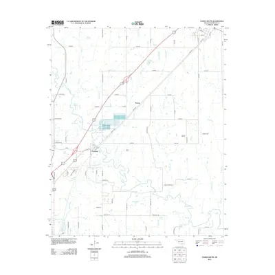
2012 Map of Caddo South
USGS Topo · Published 2012About this map
The Blue River winds through the central landscape of Bryan County, Oklahoma, creating a complex corridor of tributaries and bayous. In this 2012 survey, the settlement of Armstrong stands at a key junction where the historic Katy railroad line parallels the modern highway route. To the north, the small community of Wasseta and the landform of the Caddo Hills define the local topography. The map detail reflects the rural transition between agricultural land and the northern outskirts of Durant, shown through a network of section roads like Cooper School Rd and Three Mile Rd. Local genealogy and land history are anchored by sites such as Brown Cem and Pleasant Hill Cem, while the hydrological pattern is dominated by the meandering Mineral Bayou and Kanola Cr flowing toward the main river channel.
Find a feature on this map
66 named features on this map. Tap any name to fly to it.
Don’t see what you’re looking for? This feature index may not catch every label — zoom into the map to look around manually.
Map Details
Editions of this 2012 Caddo South Map
This is the sole edition of this map. No revisions or reprints were ever made.
Other maps of this area

1899 · Atoka
USGS Topo · 1:125,000

1900 · Atoka
USGS Topo · 1:125,000

1954 · Sherman
USGS Topo · 1:250,000

1957 · Wade
USGS Topo · 1:62,500

1957 · Ardmore
USGS Topo · 1:250,000

1958 · Durant
USGS Topo · 1:62,500

1958 · Sherman
USGS Topo · 1:250,000

1963 · Ardmore
USGS Topo · 1:250,000

1968 · Caddo NW
USGS Topo · 1:24,000
1968 · Durant North
USGS Topo · 1:24,000