
1963 Map of Ardmore
USGS Topo · Published 1963About this map
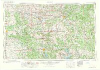
The Arbuckle Mountains dominate the central landscape of this Southern Oklahoma region, serving as a geological anchor between the developing oil fields and the water-rich valleys to the south. This 1963 survey captures the area during a period of industrial and recreational expansion, evidenced by the sprawling Ardmore Oil Field and Healdton Oil Field that drove the local economy. Water management is a defining theme, with the massive Lake Texoma and the Tishomingo National Wildlife Refuge providing a distinct contrast to the northern prairies. Significant institutional presence is visible through the Ardmore Air Force Base and the Naval Ammunition Depot, reflecting the era's military footprint. Cultural and educational hubs like East Central State College in Ada and the historic Platt National Park near Sulphur illustrate the diverse land use of the mid-20th century, from resource extraction to conservation.
Find a feature on this map
309 named features on this map. Tap any name to fly to it.
Don’t see what you’re looking for? This feature index may not catch every label — zoom into the map to look around manually.
Map Details
Editions of this 1963 Ardmore Map
2 editions found
Other maps of this area

1893 · Norman
USGS Topo · 1:62,500

1896 · Seminole and Prague
USGS Topo · 1:125,000

1896 · Coalgate
USGS Topo · 1:125,000

1898 · Purcell
USGS Topo · 1:125,000

1898 · McAlester
USGS Topo · 1:125,000

1898 · Pauls Valley
USGS Topo · 1:125,000

1899 · Coalgate
USGS Topo · 1:125,000

1899 · Atoka
USGS Topo · 1:125,000

1900 · Canadian
USGS Topo · 1:125,000

1900 · Wewoka
USGS Topo · 1:125,000