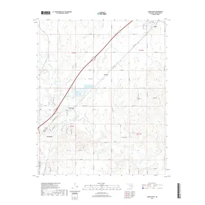
2018 Map of Caddo South
USGS Topo · Published 2018About this map
The city of Durant anchors the southwestern portion of this Bryan County landscape, where the urban grid transitions into a network of section-line roads and creek drainages. Moving northeast toward the settlement of Caddo, the topography is defined by the winding course of the Blue River and several significant tributaries, including Mineral Bayou and Johnson Creek. Significant local history is preserved in landmarks such as Brown Cemetery and Pleasant Hill Cemetery, while smaller rural nodes like Armstrong, Wasseta, and Ury mark the paths of major thoroughfares and early transportation routes. The map detail reflects a mix of modern infrastructure and long-standing rural identifiers, from the Fish Hatchery Road to the residential cluster at Caddo Hills. Large-scale features like Simmons Lake and the various branches of Thompson Creek illustrate the water resources that shaped the settlement patterns of this corner of Oklahoma.
Find a feature on this map
80 named features on this map. Tap any name to fly to it.
Don’t see what you’re looking for? This feature index may not catch every label — zoom into the map to look around manually.
Map Details
Editions of this 2018 Caddo South Map
This is the sole edition of this map. No revisions or reprints were ever made.
Other maps of this area

1899 · Atoka
USGS Topo · 1:125,000

1900 · Atoka
USGS Topo · 1:125,000

1954 · Sherman
USGS Topo · 1:250,000

1957 · Wade
USGS Topo · 1:62,500

1957 · Ardmore
USGS Topo · 1:250,000

1958 · Durant
USGS Topo · 1:62,500

1958 · Sherman
USGS Topo · 1:250,000

1963 · Ardmore
USGS Topo · 1:250,000

1968 · Caddo NW
USGS Topo · 1:24,000
1968 · Durant North
USGS Topo · 1:24,000