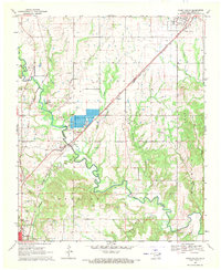
1969 Map of Caddo South
USGS Topo · Published 1971About this map
The State Fish Hatchery dominates the central landscape of this Bryan County survey, positioned north of the meandering Blue River. This region of Oklahoma, surveyed in the late 1960s, reveals a network of small settlements and transportation corridors, including the Missouri - Kansas - Texas railroad line which serves as a primary axis through Armstrong and Wasseta. To the south, the northern edge of Durant appears, featuring local infrastructure like the Durant Waterworks, a Radio Tower, and the Drive-in Theater. Rural life is marked by numerous family-named water bodies such as Thompson Creek and Harrington Creek, alongside cultural anchors like Pleasant Hill Cem and North Side Ch. The terrain transitions from the Caddo Hills in the north to the bottomlands of the Speairs area, where active Gravel Pits and Sandpits indicate the local extractive industry of the era.
Find a feature on this map
42 named features on this map. Tap any name to fly to it.
Don’t see what you’re looking for? This feature index may not catch every label — zoom into the map to look around manually.
Map Details
Editions of this 1969 Caddo South Map
This is the sole edition of this map. No revisions or reprints were ever made.
Other maps of this area

1899 · Atoka
USGS Topo · 1:125,000

1900 · Atoka
USGS Topo · 1:125,000

1954 · Sherman
USGS Topo · 1:250,000

1957 · Wade
USGS Topo · 1:62,500

1957 · Ardmore
USGS Topo · 1:250,000

1958 · Durant
USGS Topo · 1:62,500

1958 · Sherman
USGS Topo · 1:250,000

1963 · Ardmore
USGS Topo · 1:250,000

1968 · Caddo NW
USGS Topo · 1:24,000
1968 · Durant North
USGS Topo · 1:24,000