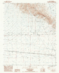
1985 Map of Cadiz
USGS Topo · Published 1985About this map
Marble Mountains dominate the northern landscape of this Mojave Desert region, where steep slopes meet the broad expanse of the Cadiz Valley. Mapping in the mid-1980s shows a landscape defined by water management and mineral extraction, with numerous Mines and Prospects scattered across the high ground. The settlement of Chambless sits along a series of protective Levees, which manage the runoff from seasonal flows like Van Winkle Wash. To the south, the railroad town of Cadiz serves as a junction point in the desert floor. The network of 4wd tracks suggests a remote area where transportation and utility infrastructure follow the natural contours of the alluvial fans.
Find a feature on this map
14 named features on this map. Tap any name to fly to it.
Don’t see what you’re looking for? This feature index may not catch every label — zoom into the map to look around manually.
Map Details
Editions of this 1985 Cadiz Map
This is the sole edition of this map. No revisions or reprints were ever made.
Other maps of this area

1942 · Amboy
USGS Topo · 1:250,000

1943 · Amboy
USGS Topo · 1:250,000

1943 · Danby
USGS Topo · 1:62,500

1943 · Cadiz Lake
USGS Topo · 1:62,500

1954 · Needles
USGS Topo · 1:250,000

1954 · Bristol Lake NW
USGS Topo · 1:24,000

1956 · Needles
USGS Topo · 1:250,000

1956 · Bristol Lake
USGS Topo · 1:62,500

1956 · Cadiz Lake
USGS Topo · 1:62,500

1956 · Cadiz
USGS Topo · 1:62,500