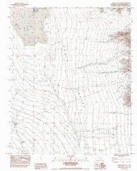
1983 Map of Cadiz Valley NE
USGS Topo · Published 1983About this map
Cadiz Dry Lake and its industrial Salt Evaporators dominate the northwestern corner of this Mojave Desert landscape. Located in the eastern San Bernardino County desert during the late 1970s, the terrain is defined by the broad floor of the Cadiz Valley, which is bounded by the Kilbeck Hills to the north and the slopes of the Iron Mountains along the eastern edge. This map reveals a specialized landscape of resource extraction, where a series of Levees and basins are engineered into the lake bed to facilitate salt production. Beyond the evaporators, the area remains largely undeveloped, characterized by numerous Dry Washes draining from the mountains and a network of primitive tracks, including a designated Jeep Trail, that provide the only access through the arid basin floor.
Find a feature on this map
12 named features on this map. Tap any name to fly to it.
Don’t see what you’re looking for? This feature index may not catch every label — zoom into the map to look around manually.
Map Details
Editions of this 1983 Cadiz Valley NE Map
This is the sole edition of this map. No revisions or reprints were ever made.
Other maps of this area

1942 · Amboy
USGS Topo · 1:250,000

1943 · Amboy
USGS Topo · 1:250,000

1943 · Cadiz Lake
USGS Topo · 1:62,500

1943 · Cadiz Valley
USGS Topo · 1:62,500

1943 · Iron Mountains
USGS Topo · 1:62,500

1954 · Needles
USGS Topo · 1:250,000

1956 · Needles
USGS Topo · 1:250,000

1956 · Milligan
USGS Topo · 1:62,500

1956 · Iron Mountains
USGS Topo · 1:62,500

1956 · Cadiz Lake
USGS Topo · 1:62,500