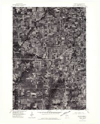
1976 Map of Cadott NE
USGS Topo · Published 1979About this map
Boyd stands as the primary population center in this rural portion of Chippewa County during the mid-1970s. This orthophotograph, derived from aerial imagery, reveals the precise distribution of woodlots, farmsteads, and the gridded agricultural fields that dominate the landscape surrounding the Yellow River. While the river snakes through the northwestern corner of the quadrangle, the southern half is defined by a more dispersed settlement pattern anchored by Edson Center. The visual nature of this 1976 survey provides a unique look at the exact land use and structural footprint of the era, contrasting the concentrated residential blocks of Boyd with the sprawling rural expanses that supported the local dairy and timber economies.
Find a feature on this map
3 named features on this map. Tap any name to fly to it.
Don’t see what you’re looking for? This feature index may not catch every label — zoom into the map to look around manually.
Map Details
Editions of this 1976 Cadott NE Map
This is the sole edition of this map. No revisions or reprints were ever made.
Other maps of this area

1951 · Cornell
USGS Topo · 1:62,500

1951 · Gilman
USGS Topo · 1:62,500

1952 · Cadott
USGS Topo · 1:62,500

1952 · Stanley
USGS Topo · 1:62,500

1953 · Eau Claire
USGS Topo · 1:250,000

1953 · Rice Lake
USGS Topo · 1:250,000

1958 · Eau Claire
USGS Topo · 1:250,000

1959 · Rice Lake
USGS Topo · 1:250,000

1964 · Eau Claire
USGS Topo · 1:250,000
1973 · Colburn
USGS Topo · 1:24,000