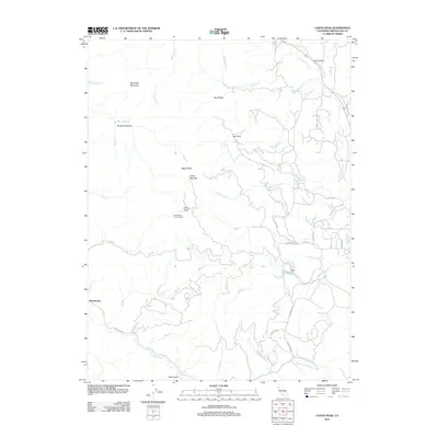
2012 Map of Cahto Peak
USGS Topo · Published 2012About this map
The settlement of Branscomb and the high summit of Cahto Peak anchor this 2012 survey of the North Coast Ranges in Mendocino County. The landscape is defined by the headwaters of the S Fork Eel River and its numerous tributaries, including Cahto Cr, Mud Cr, and Tenmile Cr. High-elevation landmarks such as the Cahto Peak Lookout Tower and Signal Peak overlook a complex topography of deep canyons and rocky outcrops, including the aptly named Paralyze Canyon and Sand Rock. Human activity in these timbered hills is represented by the Mast Mill and the clearing at Stoten Opening, while a network of rural roads like Branscomb Rd and Cahto Dr connect isolated ranching and timber properties such as Ranch Primero. The map provides a precise view of the water sources in this region, marking specific locations like Mud Springs and the convergence of Misery Cr and Elder Cr.
Find a feature on this map
48 named features on this map. Tap any name to fly to it.
Don’t see what you’re looking for? This feature index may not catch every label — zoom into the map to look around manually.
Map Details
Editions of this 2012 Cahto Peak Map
This is the sole edition of this map. No revisions or reprints were ever made.
Other maps of this area

1920 · Cummings
USGS Topo · 1:62,500

1920 · Covelo
USGS Topo · 1:62,500

1921 · Branscomb
USGS Topo · 1:62,500

1951 · Branscomb
USGS Topo · 1:62,500

1951 · Laytonville
USGS Topo · 1:62,500

1952 · Spyrock
USGS Topo · 1:62,500

1952 · Leggett
USGS Topo · 1:62,500

1957 · Ukiah
USGS Topo · 1:250,000

1960 · Ukiah
USGS Topo · 1:250,000
1966 · Dutchmans Knoll
USGS Topo · 1:24,000