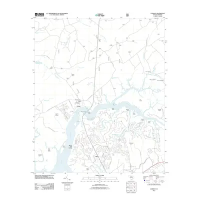
2011 Map of Cainhoy
USGS Topo · Published 2011About this map
The Wando River serves as the central artery for this South Carolina coastal landscape, where established settlements like Wando and Cainhoy sit alongside developing residential corridors. The map reveals a dense network of estuarine features including Cat Island, Goat Island, and Parker Island, woven together by a complex system of creeks such as French Quarter Creek and Toomer Creek. Local genealogy and land use are well-documented through numerous burial grounds, including Saint Thomas Cemetery, Wando Cemetery, and the McDowell Cemetery near the riverbank. Industrial and civic infrastructure is represented by the Huger Post Office, the East Cooper Airport, and the prominent Wando Lookout Tower. The shift from historical rural tracts to modern suburban planning is evident in the winding residential streets of Philip contrasted with the older crossings at Wando Bridge and Three Log Bridge.
Find a feature on this map
111 named features on this map. Tap any name to fly to it.
Don’t see what you’re looking for? This feature index may not catch every label — zoom into the map to look around manually.
Map Details
Editions of this 2011 Cainhoy Map
This is the sole edition of this map. No revisions or reprints were ever made.
Other maps of this area

1919 · Capers Island
USGS Topo · 1:21,120

1919 · Wando
USGS Topo · 1:21,120

1919 · Cordesville
USGS Topo · 1:48,000

1919 · Melgrove
USGS Topo · 1:21,120

1919 · Charleston
USGS Topo · 1:21,120

1919 · Fort Moultrie
USGS Topo · 1:21,120

1919 · Sewee Bay
USGS Topo · 1:21,120

1940 · Melgrove
USGS Topo · 1:24,000

1943 · Capers Island
USGS Topo · 1:24,000

1943 · Fort Moultrie
USGS Topo · 1:24,000