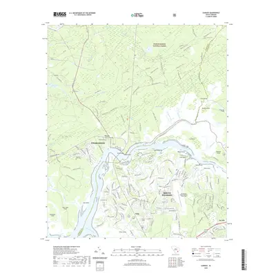
2020 Map of Cainhoy
USGS Topo · Published 2020About this map
The Wando River dominates this coastal landscape, carving a wide path through the Lowcountry as it flows toward the Atlantic. To the north, the protected woodlands of the Francis Marion National Forest are crisscrossed by the extensive Tuxbury Horse Trail, preserving a large tract of undeveloped terrain. The map captures the suburban expansion of Mount Pleasant as it grows northward, contrasted with smaller established communities like Wando, Cainhoy, and Philip. For those researching local history, several burial sites are documented, including Saint Thomas Cem near Flagg Cr and the McDowell Cem in the Wando area. The integration of modern infrastructure is evident at the Mt Pleasant Regional Airport-Faison Field, while numerous smaller waterways such as Guerin Creek and Lachicotte Creek weave through the marshlands and tidal islands that define the river's edge.
Find a feature on this map
168 named features on this map. Tap any name to fly to it.
Don’t see what you’re looking for? This feature index may not catch every label — zoom into the map to look around manually.
Map Details
Editions of this 2020 Cainhoy Map
This is the sole edition of this map. No revisions or reprints were ever made.
Other maps of this area

1919 · Capers Island
USGS Topo · 1:21,120

1919 · Wando
USGS Topo · 1:21,120

1919 · Cordesville
USGS Topo · 1:48,000

1919 · Melgrove
USGS Topo · 1:21,120

1919 · Charleston
USGS Topo · 1:21,120

1919 · Fort Moultrie
USGS Topo · 1:21,120

1919 · Sewee Bay
USGS Topo · 1:21,120

1940 · Melgrove
USGS Topo · 1:24,000

1943 · Capers Island
USGS Topo · 1:24,000

1943 · Fort Moultrie
USGS Topo · 1:24,000