1943 Map of Cakepoulin Creek
USGS Topo · Published 1943About this map
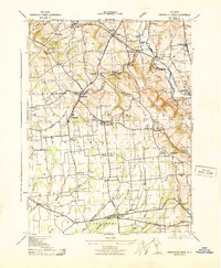
The South Branch Raritan River and the Lehigh Valley railroad corridor define the northeastern landscape of this Hunterdon County region during the early 1940s. A dense network of rural hamlets, including Pittstown, Quakertown, and Jutland, is connected by a web of early motor roads and localized landmarks. The agricultural and civic character of the area is evident in the distributed placement of the Oakgrove Grange Hall, various schools like the Independence School, and the Bethlehem Church.
Find a feature on this map
45 named features on this map. Tap any name to fly to it.
Don’t see what you’re looking for? This feature index may not catch every label — zoom into the map to look around manually.
Map Details
Editions of this 1943 Cakepoulin Creek Map
This is the sole edition of this map. No revisions or reprints were ever made.
Other maps of this area

1890 · Easton
USGS Topo · 1:62,500

1890 · High Bridge
USGS Topo · 1:62,500

1890 · Lambertville
USGS Topo · 1:62,500

1890 · Doylestown
USGS Topo · 1:62,500

1891 · Easton
USGS Topo · 1:62,500

1891 · Lambertville
USGS Topo · 1:62,500

1891 · Doylestown
USGS Topo · 1:62,500

1894 · Lambertville
USGS Topo · 1:62,500

1898 · High Bridge
USGS Topo · 1:62,500

1900 · Raritan
USGS Topo · 1:125,000