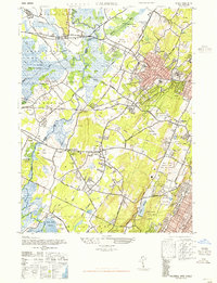
1947 Map of Caldwell
USGS Topo · Published 1947About this map
Hatfield Swamp and the Troy Meadows define the low-lying basin where the Passaic River meets the Whippany River. This postwar landscape reveals a dense network of suburban development and civic infrastructure at the border of Morris and Essex Counties. Institutional landmarks such as the Essex County Sanitarium and Essex County Penitentiary occupy significant tracts near Verona, while aviation is well-represented by the Caldwell-Wright Airport and two smaller fields near Hanover Neck. The concentration of numerous golf courses, including Greenbrook and Essex Fells, reflects the mid-century leisure-based land use patterns in this region. Local historians can trace established transit corridors like the Erie Railroad and Bloomfield Ave, which shaped the growth of Caldwell and its neighboring boroughs.
Find a feature on this map
61 named features on this map. Tap any name to fly to it.
Don’t see what you’re looking for? This feature index may not catch every label — zoom into the map to look around manually.
Map Details
Editions of this 1947 Caldwell Map
This is the sole edition of this map. No revisions or reprints were ever made.
Other maps of this area

1888 · Plainfield
USGS Topo · 1:62,500

1888 · Morristown
USGS Topo · 1:62,500

1888 · Paterson
USGS Topo · 1:62,500

1892 · Paterson
USGS Topo · 1:62,500

1893 · Plainfield
USGS Topo · 1:62,500

1894 · Morristown
USGS Topo · 1:62,500

1898 · Morristown
USGS Topo · 1:62,500

1898 · Plainfield
USGS Topo · 1:62,500

1898 · Staten Island
USGS Topo · 1:62,500

1898 · Paterson
USGS Topo · 1:62,500