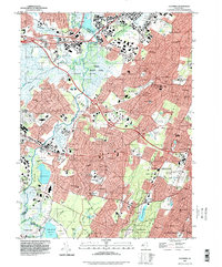
1995 Map of Caldwell
USGS Topo · Published 1998About this map
The Passaic River meanders through the heart of this landscape, separating the dense residential developments of Livingston and West Caldwell from the marshy expanses of Hatfield Swamp and Great Piece Meadows. This area reveals a complex mid-to-late 20th-century suburban environment defined by institutional landmarks and transportation hubs, including the Essex County Airport and the historic Hanover Station along the Morristown and Erie RR. Institutional presence is significant, marked by the Caldwell College for Women, Northeastern Bible Institute, and a notable concentration of municipal infrastructure such as the County Sanitarium and County Penitentiary. The geological transitions from the river lowlands to the First Watchung Mountain and Second Watchung Mountain ridges are clearly delineated, showing how these natural barriers shaped the growth of communities like Verona and West Orange.
Find a feature on this map
92 named features on this map. Tap any name to fly to it.
Don’t see what you’re looking for? This feature index may not catch every label — zoom into the map to look around manually.
Map Details
Editions of this 1995 Caldwell Map
This is the sole edition of this map. No revisions or reprints were ever made.
Other maps of this area

1888 · Plainfield
USGS Topo · 1:62,500

1888 · Morristown
USGS Topo · 1:62,500

1888 · Paterson
USGS Topo · 1:62,500

1892 · Paterson
USGS Topo · 1:62,500

1893 · Plainfield
USGS Topo · 1:62,500

1894 · Morristown
USGS Topo · 1:62,500

1898 · Morristown
USGS Topo · 1:62,500

1898 · Plainfield
USGS Topo · 1:62,500

1898 · Staten Island
USGS Topo · 1:62,500

1898 · Paterson
USGS Topo · 1:62,500