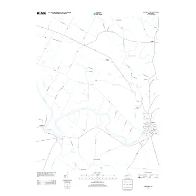
2013 Map of Calhoun
USGS Topo · Published 2013About this map
The Green River carves a winding path across this portion of McLean County, defining the spatial layout of riverside communities like Calhoun and Rumsey. These twin settlements, separated by the water, serve as the geographic anchor for the region, where a dense network of local streets including S Canal St and Riverview Dr meet the riverbanks. The landscape is dotted with distinctively named locales such as Poverty, Cleopatra, and Jewel City, each connected by a web of rural routes like Porter School House RD and Leachman School House RD. Several small aviation facilities, including Moseley Field Airport and Woosley Field Airport, are situated among the river bends and creek drainages of Eagle Cr, Pond River, and Cypress Cr. The presence of the Gravel Ford Bridge further illustrates the historical importance of river crossings in navigating this low-lying terrain.
Find a feature on this map
77 named features on this map. Tap any name to fly to it.
Don’t see what you’re looking for? This feature index may not catch every label — zoom into the map to look around manually.
Map Details
Editions of this 2013 Calhoun Map
This is the sole edition of this map. No revisions or reprints were ever made.
Other maps of this area

1906 · Sutherland
USGS Topo · 1:62,500

1908 · Calhoun
USGS Topo · 1:62,500

1909 · Madisonville
USGS Topo · 1:62,500

1909 · Central City
USGS Topo · 1:62,500

1952 · Livermore
USGS Topo · 1:24,000

1952 · Sacramento
USGS Topo · 1:24,000

1952 · Calhoun
USGS Topo · 1:24,000

1952 · Beech Grove
USGS Topo · 1:24,000

1952 · Hanson
USGS Topo · 1:24,000
1953 · Glenville
USGS Topo · 1:24,000