
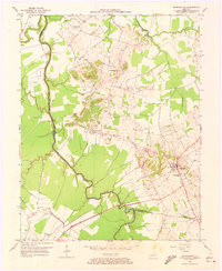
1952 Map of Sacramento
USGS Topo · Published 1953About this map
Sacramento serves as the primary hub in this early 1950s interior Kentucky landscape, where the Consolidated Sch and local cemeteries like Free Union Cem mark the community's center. The geography is defined by the winding course of the Pond River, which serves as a natural boundary between Hopkins and McLean counties. Near the river, several Oil Well symbols indicate the active extraction economy of the period, while rural life is anchored by small country churches including West Chapel, Towers Chapel, and Pack Ch.
Find a feature on this map
20 named features on this map. Tap any name to fly to it.
Don’t see what you’re looking for? This feature index may not catch every label — zoom into the map to look around manually.
Map Details
Editions of this 1952 Sacramento Map
2 editions found
Other maps of this area

1906 · Sutherland
USGS Topo · 1:62,500

1908 · Calhoun
USGS Topo · 1:62,500

1909 · Madisonville
USGS Topo · 1:62,500

1909 · Central City
USGS Topo · 1:62,500

1952 · Livermore
USGS Topo · 1:24,000

1952 · Calhoun
USGS Topo · 1:24,000

1952 · Beech Grove
USGS Topo · 1:24,000

1952 · Hanson
USGS Topo · 1:24,000

1953 · Madisonville East
USGS Topo · 1:24,000

1953 · Central City West
USGS Topo · 1:24,000