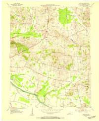
1953 Map of Glenville
USGS Topo · Published 1954About this map
The Green River meanders across the southern landscape of this mid-century survey, defining the agricultural character of southern McLean and Daviess counties. Small rural communities like Glenville and Buel serve as focal points for a region shaped by its waterways, including Long Falls Creek and Hainer Creek. The map documents a significant intersection of rural religion and industry, where country churches such as Mt Pleasant Ch and Oak Grove Ch stand alongside an active oil field and numerous oil wells. This proximity reveals the dual nature of the 1950s economy here, balancing traditional farming with subsurface extraction. From the heights of Grindstone Hill to the banks of Buck Creek, the sheet provides a meticulous view of land use, tracing the indefinite boundary lines and the dense network of drainage that feeds into the river system.
Find a feature on this map
22 named features on this map. Tap any name to fly to it.
Don’t see what you’re looking for? This feature index may not catch every label — zoom into the map to look around manually.
Map Details
Editions of this 1953 Glenville Map
2 editions found
Other maps of this area

1906 · Sutherland
USGS Topo · 1:62,500

1908 · Calhoun
USGS Topo · 1:62,500

1909 · Madisonville
USGS Topo · 1:62,500

1909 · Central City
USGS Topo · 1:62,500

1952 · Equality
USGS Topo · 1:24,000

1952 · Livermore
USGS Topo · 1:24,000

1952 · Sacramento
USGS Topo · 1:24,000

1952 · Calhoun
USGS Topo · 1:24,000

1953 · Sutherland
USGS Topo · 1:24,000

1953 · Utica
USGS Topo · 1:24,000