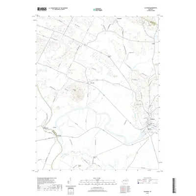
2019 Map of Calhoun
USGS Topo · Published 2019About this map
The Green River winds through the heart of McLean County, anchoring the twin communities of Calhoun and Rumsey. This riverine landscape is defined by its wide bends and the lowlands of Moseley Field, where agricultural patterns follow the natural hydrology of the valley. To the south and west, smaller settlements like Jewel City and Ashbyburg sit near the county lines, while the north is dotted with rural locales such as Poverty, Guffie, and Cleopatra. The arrangement of these communities illustrates the historical importance of river access for commerce and transit, with the primary centers of population concentrated at the river's edge. Higher ground provides a backdrop to the floodplains, creating a distinct division between the river-bottom lands and the upland farmsteads that characterize this portion of Western Kentucky.
Find a feature on this map
8 named features on this map. Tap any name to fly to it.
Don’t see what you’re looking for? This feature index may not catch every label — zoom into the map to look around manually.
Map Details
Editions of this 2019 Calhoun Map
This is the sole edition of this map. No revisions or reprints were ever made.
Other maps of this area

1906 · Sutherland
USGS Topo · 1:62,500

1908 · Calhoun
USGS Topo · 1:62,500

1909 · Madisonville
USGS Topo · 1:62,500

1909 · Central City
USGS Topo · 1:62,500

1952 · Livermore
USGS Topo · 1:24,000

1952 · Sacramento
USGS Topo · 1:24,000

1952 · Calhoun
USGS Topo · 1:24,000

1952 · Beech Grove
USGS Topo · 1:24,000

1952 · Hanson
USGS Topo · 1:24,000
1953 · Glenville
USGS Topo · 1:24,000