
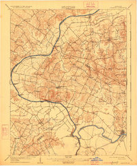
1908 Map of Calhoun
USGS Topo · Published 1908About this map
The Green River carves a winding path through this 1908 topographical survey, defining the agricultural and transport rhythms of McLean, Henderson, and Daviess counties. At the southern bend, the town of Calhoun and neighboring Rumsey serve as key river hubs, connected to the hinterlands by a network of early roads and ferry crossings. The landscape is characterized by its reliance on water-based transit before the full maturation of the regional rail system, as evidenced by several named river crossings including Steamboat Ferry, Quinn Ferry, and Eastwood Ferry.
Find a feature on this map
55 named features on this map. Tap any name to fly to it.
Don’t see what you’re looking for? This feature index may not catch every label — zoom into the map to look around manually.
Map Details
Editions of this 1908 Calhoun Map
2 editions found
Other maps of this area

1901 · Owensboro
USGS Topo · 1:62,500

1905 · Newburg
USGS Topo · 1:62,500

1906 · Sebree
USGS Topo · 1:62,500

1906 · Sutherland
USGS Topo · 1:62,500

1907 · Earlington
USGS Topo · 1:48,000

1909 · Earlington
USGS Topo · 1:62,500

1909 · Madisonville
USGS Topo · 1:62,500

1909 · Central City
USGS Topo · 1:62,500

1914 · Henderson
USGS Topo · 1:48,000

1916 · Henderson
USGS Topo · 1:62,500