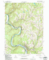
1992 Map of Callicoon
USGS Topo · Published 1994About this map
The Delaware River carves a deep, winding valley through the borderlands of New York and Pennsylvania, anchoring the riverfront settlements of Callicoon and Hankins. In the early 1990s, this area of Sullivan County remains a landscape of high ridges like Long Ridge and Cherry Ridge, punctuated by family-named landmarks and rural institutions. Institutional life is centered around St Josephs Seminary and the Delaware Valley Central Sch, while the religious history of the German and Irish settlers is visible in St Marys Ch in Obernburg and St James Ch in Callicoon.
Find a feature on this map
55 named features on this map. Tap any name to fly to it.
Don’t see what you’re looking for? This feature index may not catch every label — zoom into the map to look around manually.
Map Details
Editions of this 1992 Callicoon Map
This is the sole edition of this map. No revisions or reprints were ever made.
Other maps of this area

1920 · Long Eddy
USGS Topo · 1:62,500

1920 · Damascus
USGS Topo · 1:62,500

1921 · Long Eddy
USGS Topo · 1:48,000

1921 · Livingston Manor
USGS Topo · 1:62,500

1922 · White Lake
USGS Topo · 1:62,500

1923 · Damascus
USGS Topo · 1:62,500

1923 · Long Eddy
USGS Topo · 1:62,500

1923 · Livingston Manor
USGS Topo · 1:62,500

1942 · White Lake
USGS Topo · 1:62,500

1943 · Honesdale
USGS Topo · 1:125,000