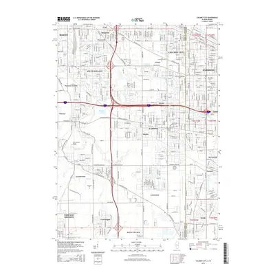
2015 Map of Calumet City
USGS Topo · Published 2015About this map
Lansing and Calumet City form the dense suburban core of this 2015 study, situated along the Illinois and Indiana border. The landscape is defined by the winding course of Thorn Creek and its many tributaries, such as Deer Creek and North Creek, which thread through established residential neighborhoods and industrial corridors. Notable for its concentration of cemeteries, the area includes historical burial grounds like Oakland Cemetery and Berger Cemetery, alongside modern landmarks like the Lansing Municipal Airport. The mapping of these borderlands reveals the intricate road network of the southern Chicago suburbs, connecting places like South Holland, Dolton, and Munster. Significant transit arteries and the Indiana Harbor Belt RR illustrate the region's enduring role as a transportation hub, while pockets of preserved space like Wampum Lake and Thorn Lake offer a contrast to the surrounding urban development.
Find a feature on this map
109 named features on this map. Tap any name to fly to it.
Don’t see what you’re looking for? This feature index may not catch every label — zoom into the map to look around manually.
Map Details
Editions of this 2015 Calumet City Map
This is the sole edition of this map. No revisions or reprints were ever made.
Other maps of this area

1892 · Calumet
USGS Topo · 1:62,500

1893 · Calumet
USGS Topo · 1:62,500

1900 · Toleston
USGS Topo · 1:62,500

1900 · Calumet
USGS Topo · 1:62,500

1901 · Calumet
USGS Topo · 1:62,500

1929 · Calumet Lake
USGS Topo · 1:24,000

1929 · Calumet City
USGS Topo · 1:24,000
1929 · Blue Island
USGS Topo · 1:24,000

1929 · Harvey
USGS Topo · 1:24,000

1929 · Dyer
USGS Topo · 1:24,000