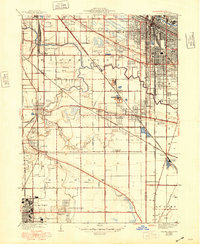
1929 Map of Calumet City
USGS Topo · Published 1948About this map
The Little Calumet River and Grand Calumet R define the drainage of this industrial and residential landscape spanning the Illinois and Indiana border. Established rail lines including the Pennsylvania Road and Baltimore and Ohio Chicago Terminal cross the terrain, supporting local industry represented by multiple Brickyard sites. The map reveals the early 20th-century development of Calumet City and Hammond, contrasting dense urban street grids with the sprawling grounds of Holy Cross Cemetery, Mt Forest Cemetery, and Concordia Cemetery. Major transit arteries like the Lincoln Highway and Ridge Road connect established settlements such as Dolton and Lansing with outlying rural schoolhouses like Sand Ridge School and Sunnybrook School, illustrating the transition from agrarian roots to a burgeoning suburban and industrial corridor during the late 1920s.
Find a feature on this map
53 named features on this map. Tap any name to fly to it.
Don’t see what you’re looking for? This feature index may not catch every label — zoom into the map to look around manually.
Map Details
Editions of this 1929 Calumet City Map
3 editions found
Other maps of this area

1892 · Calumet
USGS Topo · 1:62,500

1893 · Calumet
USGS Topo · 1:62,500

1900 · Toleston
USGS Topo · 1:62,500

1900 · Calumet
USGS Topo · 1:62,500

1901 · Calumet
USGS Topo · 1:62,500

1929 · Calumet Lake
USGS Topo · 1:24,000

1929 · Calumet City
USGS Topo · 1:24,000
1929 · Blue Island
USGS Topo · 1:24,000

1929 · Harvey
USGS Topo · 1:24,000

1929 · Dyer
USGS Topo · 1:24,000