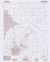
1985 Map of Calumet Mine
USGS Topo · Published 1985About this map
Calumet Mountains dominate the southern portion of this desert landscape, where steep contours give way to the broad expanse of Bristol Lake to the northwest. The map captures a transitional zone between the arid peaks and the flat, salt-crusted basin of the lake, reflecting the characteristic geography of the eastern Mojave. Evidence of human enterprise is sparse but significant, featuring a long Pipeline corridor and a small Prospect located near the northern foothills of the range. To the east, the land opens into the Cadiz Valley, showing a landscape defined by natural drainage patterns and the remote infrastructure required for desert resource management in the mid-1980s.
Find a feature on this map
9 named features on this map. Tap any name to fly to it.
Don’t see what you’re looking for? This feature index may not catch every label — zoom into the map to look around manually.
Map Details
Editions of this 1985 Calumet Mine Map
This is the sole edition of this map. No revisions or reprints were ever made.
Other maps of this area

1942 · Amboy
USGS Topo · 1:250,000

1943 · Amboy
USGS Topo · 1:250,000

1943 · Danby
USGS Topo · 1:62,500

1943 · Cadiz Lake
USGS Topo · 1:62,500

1954 · Needles
USGS Topo · 1:250,000

1954 · Bristol Lake NW
USGS Topo · 1:24,000

1954 · Bristol Lake SW
USGS Topo · 1:24,000

1956 · Needles
USGS Topo · 1:250,000

1956 · Bristol Lake
USGS Topo · 1:62,500

1956 · Cadiz Lake
USGS Topo · 1:62,500