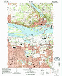
1993 Map of Camas
USGS Topo · Published 1996About this map
The Columbia River serves as the focal point for this survey, dividing the industrial and residential corridors of Camas, Washington, from the expanding suburbs of Troutdale and Gresham, Oregon. Industry is heavily represented by the massive Aluminum Plant on the Oregon shore and the Fisher Quarry near the riverbanks. The transportation network is highly developed, showing the Portland-Troutdale Airport and the complex rail infrastructure of the Union Pacific and MAX Rail lines.
Find a feature on this map
82 named features on this map. Tap any name to fly to it.
Don’t see what you’re looking for? This feature index may not catch every label — zoom into the map to look around manually.
Map Details
Editions of this 1993 Camas Map
This is the sole edition of this map. No revisions or reprints were ever made.
Other maps of this area

1897 · Portland
USGS Topo · 1:62,500

1905 · Portland
USGS Topo · 1:62,500

1911 · Boring
USGS Topo · 1:48,000

1914 · Boring
USGS Topo · 1:62,500

1914 · Oregon City
USGS Topo · 1:62,500

1916 · Estacada
USGS Topo · 1:125,000

1918 · Troutdale
USGS Topo · 1:62,500

1934 · Troutdale
USGS Topo · 1:48,000

1939 · Oregon City
USGS Topo · 1:62,500

1940 · Boring
USGS Topo · 1:62,500