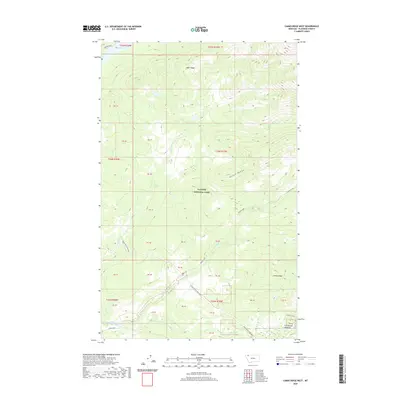
2020 Map of Camas Ridge West
USGS Topo · Published 2020About this map
Glacier National Park defines this area of northwestern Montana, where deep drainages and sharp ridges dominate the landscape. The Inside North Fork Road winds through the central valley, providing a primary route across a region defined by the waters of Dutch Creek and Camas Creek. Local history and land use are evidenced by named clearings like Christensen Meadows, which sit in contrast to the heavily forested slopes of Adair Ridge and Camas Ridge. To the north, the tip of Logging Lake reaches into the frame, marking one of the many glacial water bodies that characterize this high country. The map's detail preserves the network of small tributaries like Anaconda Cr and McGee Cr, alongside specific land parcels identified as PB units, illustrating the modern management and historical boundary divisions within the park's interior.
Find a feature on this map
31 named features on this map. Tap any name to fly to it.
Don’t see what you’re looking for? This feature index may not catch every label — zoom into the map to look around manually.
Map Details
Editions of this 2020 Camas Ridge West Map
This is the sole edition of this map. No revisions or reprints were ever made.
Other maps of this area

1904 · Chief Mountain
USGS Topo · 1:125,000

1906 · Kintla Lakes
USGS Topo · 1:125,000

1938 · Chief Mountain
USGS Topo · 1:125,000

1938 · Kintla Lakes
USGS Topo · 1:125,000

1957 · Kalispell
USGS Topo · 1:250,000

1960 · Kalispell
USGS Topo · 1:250,000

1960 · Cut Bank
USGS Topo · 1:250,000

1961 · Kalispell
USGS Topo · 1:250,000

1963 · Cut Bank
USGS Topo · 1:250,000

1964 · Cut Bank
USGS Topo · 1:250,000