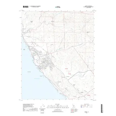
2018 Map of Cambria
USGS Topo · Published 2018About this map
Cambria anchors this coastal survey, where the residential street grid meets the Pacific edge at Moonstone Beach and Leffingwell Cove. The landscape transitions from the developed pines and neighborhoods like Cambria Pines Rd to the open agricultural and ranch lands of the Santa Lucia Range foothills. Inland, the small settlement of Harmony sits within Harmony Valley, reflecting the area's rural dairy and ranching heritage. Notable for genealogists are the Cambria Cem and Santa Rosa Cem, located near the winding path of Santa Rosa Cr. The map details a sophisticated network of local trails, including the Gary Santa Rosa Creek Trail and various paths within San Simeon State Park, illustrating how the community integrated recreation with its unique geography of marine terraces and coastal ridges like Estrada Ridge.
Find a feature on this map
114 named features on this map. Tap any name to fly to it.
Don’t see what you’re looking for? This feature index may not catch every label — zoom into the map to look around manually.
Map Details
Editions of this 2018 Cambria Map
This is the sole edition of this map. No revisions or reprints were ever made.
Other maps of this area

1897 · Cayucos
USGS Topo · 1:62,500

1900 · San Luis
USGS Topo · 1:125,000

1919 · Adelaida
USGS Topo · 1:62,500

1919 · San Simeon
USGS Topo · 1:62,500

1932 · Adelaida
USGS Topo · 1:62,500

1937 · Cayucos
USGS Topo · 1:62,500

1937 · San Simeon
USGS Topo · 1:62,500

1942 · Adelaida
USGS Topo · 1:62,500

1943 · Cayucos
USGS Topo · 1:62,500

1947 · San Luis Obispo
USGS Topo · 1:250,000