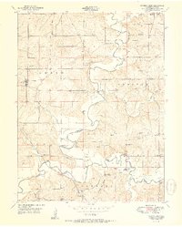
1951 Map of Camden Point
USGS Topo · Published 1951About this map
The Platte River and its meandering tributary, the Little Platte River, define the landscape of northern Platte County in this mid-century survey. The terrain is marked by a high density of rural social infrastructure, including family-named burial grounds like Standiford Cem, Lutes Cem, and McComas Cem, which serve as vital markers for genealogical research. The river crossings are central to the local geography, featuring the notable Covered Bridge and Skinner Bridge. Small rural hubs such as Edgerton and Camden Point are connected by a network of one-room schoolhouses like Franklin Sch and Horn Sch. This map captures the area just before modern highway expansions altered the traditional boundaries of Green, Preston, and Fair townships, preserving the locations of vanished landmarks like Sharps Station and Kerrville.
Find a feature on this map
52 named features on this map. Tap any name to fly to it.
Don’t see what you’re looking for? This feature index may not catch every label — zoom into the map to look around manually.
Map Details
Editions of this 1951 Camden Point Map
2 editions found
Other maps of this area

1890 · Kansas City
USGS Topo · 1:125,000

1894 · Kansas City
USGS Topo · 1:125,000

1910 · Leavenworth
USGS Topo · 1:62,500

1914 · Smithville
USGS Topo · 1:62,500

1925 · Gower
USGS Topo · 1:62,500

1927 · Dearborn
USGS Topo · 1:62,500
1948 · Nashua
USGS Topo · 1:24,000

1948 · Leavenworth
USGS Topo · 1:62,500

1950 · Kansas City
USGS Topo · 1:250,000
1950 · Nashua
USGS Topo · 1:24,000