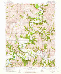
1961 Map of Camden Point
USGS Topo · Published 1962About this map
The Platte River and Little Platte River define the winding, low-lying topography of this region in Platte County during the early 1960s. Evidence of earlier transportation infrastructure is preserved in the form of an Old Railroad Grade stretching toward Edgerton Junction, marking the path of a rail network that once connected small agricultural hubs like Camden Point and Sharps Station. This survey provides a detailed look at the social fabric of the rural landscape, documenting numerous family and community burial grounds including the McComas Cem, Cockrell Cem, and Unity Cem. Water features such as Goose Neck and Turners Lake punctuate the river bottoms, while the crossing at Mellon Bridge serves as a vital point of transit over the meandering waters of the Platte.
Find a feature on this map
36 named features on this map. Tap any name to fly to it.
Don’t see what you’re looking for? This feature index may not catch every label — zoom into the map to look around manually.
Map Details
Editions of this 1961 Camden Point Map
2 editions found
Other maps of this area

1890 · Kansas City
USGS Topo · 1:125,000

1894 · Kansas City
USGS Topo · 1:125,000

1910 · Leavenworth
USGS Topo · 1:62,500

1914 · Smithville
USGS Topo · 1:62,500

1925 · Gower
USGS Topo · 1:62,500

1927 · Dearborn
USGS Topo · 1:62,500
1948 · Nashua
USGS Topo · 1:24,000

1948 · Leavenworth
USGS Topo · 1:62,500

1950 · Kansas City
USGS Topo · 1:250,000
1950 · Nashua
USGS Topo · 1:24,000