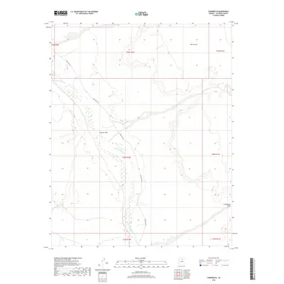
2018 Map of Cameron SE
USGS Topo · Published 2018About this map
The Little Colorado River winds through the high desert of Coconino County, serving as the dominant hydrological feature of this arid landscape. This 2018 survey illustrates a region defined by complex drainage systems and significant geological formations, most notably the expansive Ward Terrace to the northeast. The presence of Indian Rte 6730 provides the primary transit corridor through the territory, following the general path of the river valley. The topography is marked by several seasonal drainages including Landmark Wash and To Nahakaad Wash, which cut through the sedimentary layers of the Painted Desert region. The map highlights the vast, open character of this part of the Navajo Nation, where the interplay between the river's path and the surrounding terraces dictates the local geography.
Find a feature on this map
12 named features on this map. Tap any name to fly to it.
Don’t see what you’re looking for? This feature index may not catch every label — zoom into the map to look around manually.
Map Details
Editions of this 2018 Cameron SE Map
This is the sole edition of this map. No revisions or reprints were ever made.
Other maps of this area

1886 · San Francisco Mtns
USGS Topo · 1:250,000

1891 · San Francisco Mtns
USGS Topo · 1:250,000

1894 · San Francisco Mtns
USGS Topo · 1:250,000

1899 · San Francisco Mtns
USGS Topo · 1:250,000

1947 · Flagstaff
USGS Topo · 1:250,000

1954 · Flagstaff
USGS Topo · 1:250,000

1955 · Black Falls NE
USGS Topo · 1:24,000

1955 · Cameron SW
USGS Topo · 1:24,000
1955 · Cameron SE
USGS Topo · 1:24,000

1955 · Cameron
USGS Topo · 1:62,500