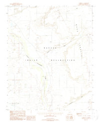
1988 Map of Cameron SE
USGS Topo · Published 1988About this map
The Little Colorado River winds through the heart of this high-desert landscape on the Navajo Indian Reservation, serving as the primary drainage for the surrounding arid terrain. Along the river’s path, the map identifies various human impacts on the earth, from a Borrow Pit to several instances of an Open Pit Mine with associated Tailings. These industrial footprints stand in contrast to the natural geologic formations that define the area, most notably the expansive Ward Terrace to the east and the prominent feature known as The Landmark.
Find a feature on this map
14 named features on this map. Tap any name to fly to it.
Don’t see what you’re looking for? This feature index may not catch every label — zoom into the map to look around manually.
Map Details
Editions of this 1988 Cameron SE Map
This is the sole edition of this map. No revisions or reprints were ever made.
Other maps of this area

1886 · San Francisco Mtns
USGS Topo · 1:250,000

1891 · San Francisco Mtns
USGS Topo · 1:250,000

1894 · San Francisco Mtns
USGS Topo · 1:250,000

1899 · San Francisco Mtns
USGS Topo · 1:250,000

1947 · Flagstaff
USGS Topo · 1:250,000

1954 · Flagstaff
USGS Topo · 1:250,000

1955 · Black Falls NE
USGS Topo · 1:24,000

1955 · Cameron SW
USGS Topo · 1:24,000
1955 · Cameron SE
USGS Topo · 1:24,000

1955 · Cameron
USGS Topo · 1:62,500