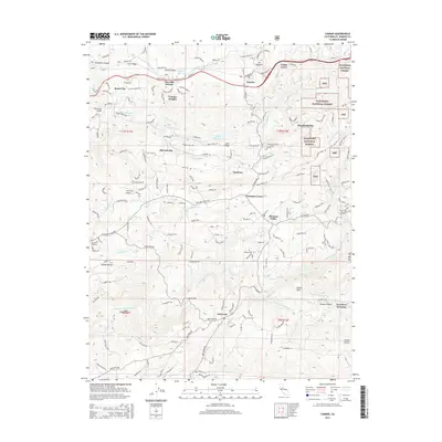
2015 Map of Camino
USGS Topo · Published 2015About this map
The North Fork Cosumnes River and its various tributaries define the complex hydrology of this part of El Dorado County. The landscape is marked by a sophisticated network of water management features, including the El Dorado Irrigation Main Canal, New Weber Ditch, and Crawford Ditch, reflecting the region's long-standing reliance on water diversion for agriculture and mining. Settled areas like Camino, Cedar Grove, and Somerset are interspersed with smaller locales such as Fruit Ridge and Old Fort Jim.
Find a feature on this map
55 named features on this map. Tap any name to fly to it.
Don’t see what you’re looking for? This feature index may not catch every label — zoom into the map to look around manually.
Map Details
Editions of this 2015 Camino Map
This is the sole edition of this map. No revisions or reprints were ever made.
Other maps of this area

1891 · Placerville
USGS Topo · 1:125,000

1892 · Placerville
USGS Topo · 1:125,000

1893 · Placerville
USGS Topo · 1:125,000

1947 · Sacramento
USGS Topo · 1:250,000

1948 · Sacramento
USGS Topo · 1:250,000

1949 · Georgetown
USGS Topo · 1:62,500

1949 · Placerville
USGS Topo · 1:62,500

1949 · Placerville
USGS Topo · 1:24,000
1949 · Fiddletown
USGS Topo · 1:24,000
1949 · Garden Valley
USGS Topo · 1:24,000