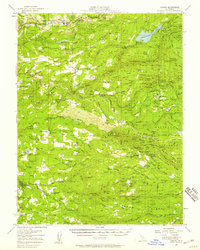
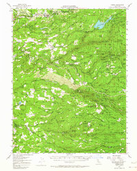
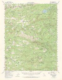
1952 Map of Camino
USGS Topo · Published 1959About this map
Camino and the surrounding timber and mining lands of the Sierra Nevada foothills are captured here during a period of transition in the mid-twentieth century. The landscape is defined by the deep canyons of the North Fork Cosumnes River and its branches, where decades of resource extraction left a dense network of claims. From the northern fruit-growing ridges near Five Mile Terrace to the southern reach of Omo Ranch, the map reveals a rugged geography stitched together by irrigation ditches like the Caldor Ditch and historic routes such as the Mormon Emigrant Trail. Local history is preserved in the locations of numerous one-room schoolhouses, including Indian Diggings Sch and Blair Dist Sch, alongside landmarks of early California history like Old Fort Jim. A complex mining economy is evident through dozens of named sites like the Yellow Aster Mine and Gold Note Mine, which once supported now-diminished settlements across the Eldorado National Forest.
Find a feature on this map
136 named features on this map. Tap any name to fly to it.
Don’t see what you’re looking for? This feature index may not catch every label — zoom into the map to look around manually.
Map Details
Editions of this 1952 Camino Map
3 editions found
Other maps of this area

1889 · Jackson
USGS Topo · 1:125,000

1889 · Pyramid Peak
USGS Topo · 1:125,000

1891 · Big Trees
USGS Topo · 1:125,000

1891 · Placerville
USGS Topo · 1:125,000

1891 · Pyramid Peak
USGS Topo · 1:125,000

1892 · Jackson
USGS Topo · 1:125,000

1892 · Placerville
USGS Topo · 1:125,000

1893 · Placerville
USGS Topo · 1:125,000

1894 · Big Trees
USGS Topo · 1:125,000

1895 · Pyramid Peak
USGS Topo · 1:125,000