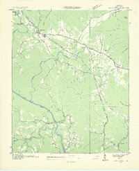
1935 Map of Camp Austin
USGS Topo · Published 1935About this map
Wartburg serves as the primary hub of this Morgan County landscape, where the Cumberland Plateau meets the winding Emory River. This 1935 survey by the Tennessee Valley Authority and USGS reveals a rural community supported by a network of one-room schools like Deermont Sch, White Oak Sch, and Piney Sch. The economic life of the era is marked by the Southern railroad line cutting through the valley and the presence of the CCC Camp No 1463 near the river's edge, reflecting New Deal-era activity in the Tennessee Valley.
Find a feature on this map
44 named features on this map. Tap any name to fly to it.
Don’t see what you’re looking for? This feature index may not catch every label — zoom into the map to look around manually.
Map Details
Editions of this 1935 Camp Austin Map
2 editions found

Other maps of this area

1887 · Kingston
USGS Topo · 1:125,000

1891 · Kingston
USGS Topo · 1:125,000

1893 · Briceville
USGS Topo · 1:125,000

1893 · Kingston
USGS Topo · 1:125,000

1895 · Wartburg
USGS Topo · 1:125,000

1895 · Loudon
USGS Topo · 1:125,000

1895 · Briceville
USGS Topo · 1:125,000

1896 · Wartburg
USGS Topo · 1:125,000

1896 · Briceville
USGS Topo · 1:125,000

1935 · Gobey
USGS Topo · 1:24,000