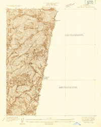
1934 Map of Camp Baldy
USGS Topo · Published 1934About this map
The San Gabriel Mountains dominate this 1934 survey, centered on the high elevation terrain surrounding Mt San Antonio (Old Baldy). At this time, the area served as a critical recreation and resource hub for Los Angeles County, evidenced by the presence of Camp Baldy and the San Antonio Camp situated along the steep drainages. The landscape is marked by the infrastructure of early 20th-century forest management and mining, including the Old Baldy Lookout and the Bear Canyon R.S.. Resource extraction is represented by the Gold Dollar Mine and Eagle Mine located in the high canyons. The intricate network of Trail and Firebreak annotations reveals the early development of mountain access and fire suppression strategies in the San Gabriels, while features like the Hog Back and Sunset Peak Lookout provide specific navigational points for researchers studying the historical topography of the region.
Find a feature on this map
23 named features on this map. Tap any name to fly to it.
Don’t see what you’re looking for? This feature index may not catch every label — zoom into the map to look around manually.
Map Details
Editions of this 1934 Camp Baldy Map
This is the sole edition of this map. No revisions or reprints were ever made.
Other maps of this area

1897 · Cucamonga
USGS Topo · 1:62,500

1900 · Cucamonga
USGS Topo · 1:62,500

1901 · Southern California Sheet No. 1
USGS Topo · 1:250,000

1903 · Cucamonga
USGS Topo · 1:62,500

1903 · San Antonio
USGS Topo · 1:62,500

1904 · Southern California Sheet No. 1
USGS Topo · 1:250,000
1928 · La Verne
USGS Topo · 1:24,000
1933 · La Verne and Evey Canyon
USGS Topo · 1:24,000

1934 · Camp Bonita
USGS Topo · 1:24,000
1936 · Mt. Baden-Powell
USGS Topo · 1:24,000