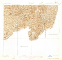
1933 Map of La Verne and Evey Canyon
USGS Topo · Published 1933About this map
San Gabriel Mountains dominate this 1933 advance sheet, revealing a landscape of steep canyons and forest management before major mid-century developments. Within the Angeles National Forest, the map identifies early conservation and infrastructure efforts like the Flintham Memorial Forest Plantation and the San Dimas Lookout. The presence of the San Dimas Dam highlights the era's focus on water management and flood control for the growing communities in the valley below. Local landmarks such as Wolfskill Camp and the dramatic Wolfskill Falls suggest a period when these canyons were primarily accessed for recreation and forest service work. High-altitude clearings like Browns Flat and Sycamore Flat provide unique topographical markers amidst the intricate drainage systems of San Dimas Canyon and Evey Canyon.
Find a feature on this map
19 named features on this map. Tap any name to fly to it.
Don’t see what you’re looking for? This feature index may not catch every label — zoom into the map to look around manually.
Map Details
Editions of this 1933 La Verne and Evey Canyon Map
This is the sole edition of this map. No revisions or reprints were ever made.
Other maps of this area

1894 · Pomona
USGS Topo · 1:62,500

1897 · Pomona
USGS Topo · 1:62,500

1897 · Cucamonga
USGS Topo · 1:62,500

1898 · Pomona
USGS Topo · 1:62,500

1900 · Cucamonga
USGS Topo · 1:62,500

1901 · Southern California Sheet No. 1
USGS Topo · 1:250,000

1903 · Cucamonga
USGS Topo · 1:62,500

1904 · Pomona
USGS Topo · 1:62,500

1904 · Southern California Sheet No. 1
USGS Topo · 1:250,000
1927 · Glendora
USGS Topo · 1:24,000