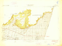
1928 Map of La Verne
USGS Topo · Published 1928About this map
La Verne and Claremont anchor the southern plains of this mid-1920s survey, where the grid of early citrus-era development meets the rising foothills of the Angeles National Forest. The landscape is defined by the San Bernardino Base Line, which serves as a primary axis for the region's transport and settlement. Institutional life is well-documented through landmarks like Bonita High School, the La Verne Heights School, and the remote Webb School nestled near the canyon mouths.
Find a feature on this map
49 named features on this map. Tap any name to fly to it.
Don’t see what you’re looking for? This feature index may not catch every label — zoom into the map to look around manually.
Map Details
Editions of this 1928 La Verne Map
2 editions found
Other maps of this area

1894 · Pomona
USGS Topo · 1:62,500

1897 · Pomona
USGS Topo · 1:62,500

1897 · Cucamonga
USGS Topo · 1:62,500

1898 · Pomona
USGS Topo · 1:62,500

1900 · Cucamonga
USGS Topo · 1:62,500

1901 · Southern California Sheet No. 1
USGS Topo · 1:250,000

1903 · Cucamonga
USGS Topo · 1:62,500

1904 · Pomona
USGS Topo · 1:62,500

1904 · Southern California Sheet No. 1
USGS Topo · 1:250,000
1927 · Glendora
USGS Topo · 1:24,000