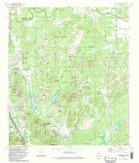
1992 Map of Camp Bullis
USGS Topo · Published 1992About this map
Camp Bullis Military Reservation dominates this landscape north of the San Antonio corporate boundary, where the Texas hill country meets expanding suburban development. The 1990s terrain is marked by a complex network of ridges and hills, including McCaskey Ridge, Sykes Hill, and Neutze Hill, providing the elevation necessary for military training exercises. Grounded in mid-century field data and revised by 1980s aerial photography, the map captures the contrast between the tactical landscape of the Firing Range and the burgeoning residential character of Fair Oaks Ranch. Local history seekers will find small, specific landmarks like the Garfes Cem and the German Tank, along with natural water features such as Sewell Pond and the winding course of Cibolo Creek. The presence of Friedrich Park at the southern edge highlights the area's transition into a managed natural space as San Antonio pushed northward.
Find a feature on this map
78 named features on this map. Tap any name to fly to it.
Don’t see what you’re looking for? This feature index may not catch every label — zoom into the map to look around manually.
Map Details
Editions of this 1992 Camp Bullis Map
This is the sole edition of this map. No revisions or reprints were ever made.
Other maps of this area

1920 · Smithsons Valley
USGS Topo · 1:62,500

1927 · Smithson Valley
USGS Topo · 1:62,500

1929 · Smithson Valley
USGS Topo · 1:62,500

1940 · Smithson Valley
USGS Topo · 1:62,500

1953 · Otis Ridge
USGS Topo · 1:24,000

1953 · Bulverde
USGS Topo · 1:24,000

1953 · Longhorn
USGS Topo · 1:24,000

1953 · Helotes
USGS Topo · 1:24,000

1953 · Castle Hills
USGS Topo · 1:24,000

1953 · Van Raub
USGS Topo · 1:24,000