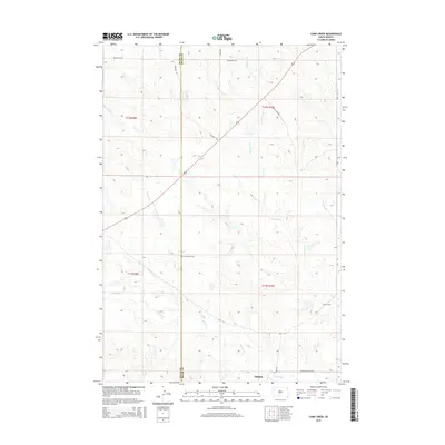
2015 Map of Camp Creek
USGS Topo · Published 2015About this map
Plum Draw Cem stands as a quiet landmark in this high plains landscape along the Butte County and Meade County line. The map highlights a drainage network defined by the seasonal flow of Camp Creek, Plum Cr, and Sulphur Cr, which converge near the small settlement of Sulphur. This era of the Dakotas is reflected in the transition from traditional section-line travel to modern routes like the Sulphur Cut Off Rd and Mud Butte Rd. The proximity of local markers such as Kittyhawk Pl and Keyhole Rd suggests a landscape managed for ranching and limited rural habitation, where water sources and family burial grounds remain the primary fixed points of historical interest.
Find a feature on this map
18 named features on this map. Tap any name to fly to it.
Don’t see what you’re looking for? This feature index may not catch every label — zoom into the map to look around manually.
Map Details
Editions of this 2015 Camp Creek Map
This is the sole edition of this map. No revisions or reprints were ever made.
Other maps of this area

1913 · Newell
USGS Topo · 1:125,000

1935 · Hoover
USGS Topo · 1:125,000

1953 · Rapid City
USGS Topo · 1:250,000

1954 · Lemmon
USGS Topo · 1:250,000

1957 · Lemmon
USGS Topo · 1:250,000

1957 · Rapid City
USGS Topo · 1:250,000

1973 · Frozen Man Creek
USGS Topo · 1:24,000

1977 · Table Top Butte
USGS Topo · 1:24,000
1977 · Owl Butte SE
USGS Topo · 1:24,000
1978 · Owl Butte NE
USGS Topo · 1:24,000