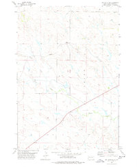
1978 Map of Owl Butte NE
USGS Topo · Published 1978About this map
Sulphur Creek and its southern tributaries dominate this landscape in western South Dakota, where the topography is defined by open prairie and intermittent drainage patterns. The map shows the land just after the mid-1970s, characterized by ranching infrastructure and isolated survey markers. Water management is central to the area's utility, evidenced by the presence of a Well and a Drill Hole in the northern sections. Along with Trail Creek and Doody Creek, these waterways suggest a landscape where seasonal flow dictates the movement of people and livestock. The 1978 edition reflects a quiet period of rural land use, documented with precision by the U.S. Geological Survey through photogrammetric methods.
Find a feature on this map
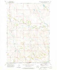
7 named features on this map. Tap any name to fly to it.
Don’t see what you’re looking for? This feature index may not catch every label — zoom into the map to look around manually.
Map Details
Editions of this 1978 Owl Butte NE Map
This is the sole edition of this map. No revisions or reprints were ever made.
Other maps of this area

1913 · Newell
USGS Topo · 1:125,000

1935 · Hoover
USGS Topo · 1:125,000

1953 · Rapid City
USGS Topo · 1:250,000

1954 · Lemmon
USGS Topo · 1:250,000

1957 · Lemmon
USGS Topo · 1:250,000

1957 · Rapid City
USGS Topo · 1:250,000
1973 · Deers Ears Butte North
USGS Topo · 1:24,000
1973 · Owl Butte
USGS Topo · 1:24,000
1977 · Deers Ears Butte South
USGS Topo · 1:24,000

1977 · Table Top Butte
USGS Topo · 1:24,000