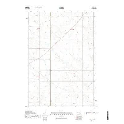
2017 Map of Camp Creek
USGS Topo · Published 2017About this map
Sulphur and the neighboring settlement of Camp Creek anchor this prairie landscape along the border of Butte and Meade Counties. The terrain is defined by the drainage networks of Plum Cr, Lottie Cr, and the larger Sulphur Cr, which carve through the high plains. A significant landmark for local history and genealogy is the Plum Draw Cem, situated near the confluence of local drainages. The map reveals a remote ranching and agricultural infrastructure connected by a network of rural routes including Mud Butte Rd, Sulphur Cut Off Rd, and Keyhole Rd. These corridors, along with Old 212, illustrate the enduring transportation patterns of the West River region, where section lines and creek beds dictate the placement of homes and livestock operations.
Find a feature on this map
19 named features on this map. Tap any name to fly to it.
Don’t see what you’re looking for? This feature index may not catch every label — zoom into the map to look around manually.
Map Details
Editions of this 2017 Camp Creek Map
This is the sole edition of this map. No revisions or reprints were ever made.
Other maps of this area

1913 · Newell
USGS Topo · 1:125,000

1935 · Hoover
USGS Topo · 1:125,000

1953 · Rapid City
USGS Topo · 1:250,000

1954 · Lemmon
USGS Topo · 1:250,000

1957 · Lemmon
USGS Topo · 1:250,000

1957 · Rapid City
USGS Topo · 1:250,000

1973 · Frozen Man Creek
USGS Topo · 1:24,000

1977 · Table Top Butte
USGS Topo · 1:24,000
1977 · Owl Butte SE
USGS Topo · 1:24,000
1978 · Owl Butte NE
USGS Topo · 1:24,000