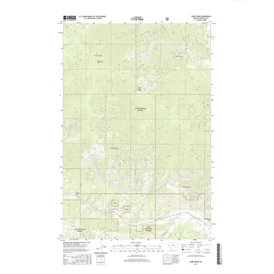
2017 Map of Camp Creek
USGS Topo · Published 2017About this map
Lolo National Forest dominates this section of Missoula County, where the high ridges of the Grave Creek Range meet the deep drainages of the Lolo watershed. This 2017 survey details a landscape defined by its hydrography and forestry access, anchored by peaks like Telephone Butte and carved by numerous gulches. Evidence of early water management for ranching or mining persists in the Williams Preston Hovet Ditch, which follows the contours above Lolo Creek. The network of forest service roads, including Deep Creek Rd and Bear Creek Rd, provides the primary infrastructure through these mountains. Local history is etched into the terrain through place names such as Schoolhouse Gulch and Potato Gulch, suggesting former uses of the land before it was consolidated under federal forest management.
Find a feature on this map
28 named features on this map. Tap any name to fly to it.
Don’t see what you’re looking for? This feature index may not catch every label — zoom into the map to look around manually.
Map Details
Editions of this 2017 Camp Creek Map
This is the sole edition of this map. No revisions or reprints were ever made.
Other maps of this area

1912 · Missoula
USGS Topo · 1:125,000

1956 · Hamilton
USGS Topo · 1:250,000

1959 · Hamilton
USGS Topo · 1:250,000

1960 · Hamilton
USGS Topo · 1:250,000

1963 · Primrose
USGS Topo · 1:24,000

1964 · Hamilton
USGS Topo · 1:250,000
1964 · Diamond Point
USGS Topo · 1:24,000

1964 · Garden Point
USGS Topo · 1:24,000

1964 · Dick Creek
USGS Topo · 1:24,000

1964 · West Fork Butte
USGS Topo · 1:24,000