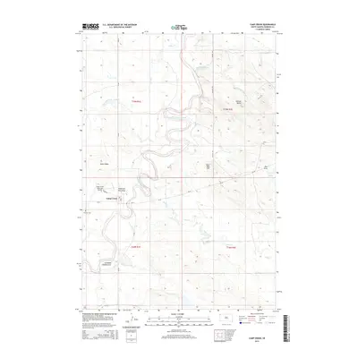
2015 Map of Camp Crook
USGS Topo · Published 2015About this map
The Little Missouri River meanders through the heart of this Harding County landscape, defining the topography of Camp Crook. The town sits at a bend in the river, supported by a network of rural routes like SD-20 and Rodeo Rd. The surrounding terrain is marked by distinctive local landmarks, including the prominent Johnson Butte to the northeast and the elevated Battle Ridge to the west. This 2015 survey captures a mix of ranching infrastructure and natural drainage features, from the family-named Grandma Schang Draw to the Hoag Coal Mine Draw, reflecting the area's agricultural and resource-based history. Further south, the community is served by the Camp Crook Municipal Airport and the nearby Fairview Cemetery. This map provides a detailed look at the drainage systems of Buffalo Springs Creek and Valley Creek, illustrating the remote prairie character of northwestern South Dakota.
Find a feature on this map
28 named features on this map. Tap any name to fly to it.
Don’t see what you’re looking for? This feature index may not catch every label — zoom into the map to look around manually.
Map Details
Editions of this 2015 Camp Crook Map
This is the sole edition of this map. No revisions or reprints were ever made.
Other maps of this area

1935 · Harding
USGS Topo · 1:125,000

1935 · Buffalo
USGS Topo · 1:125,000

1954 · Lemmon
USGS Topo · 1:250,000

1954 · Ekalaka
USGS Topo · 1:250,000

1956 · Ekalaka
USGS Topo · 1:250,000

1957 · Lemmon
USGS Topo · 1:250,000

1958 · Ekalaka
USGS Topo · 1:250,000

1965 · Ekalaka
USGS Topo · 1:250,000

1973 · Gallup Creek
USGS Topo · 1:24,000

1974 · Caroline Butte
USGS Topo · 1:24,000