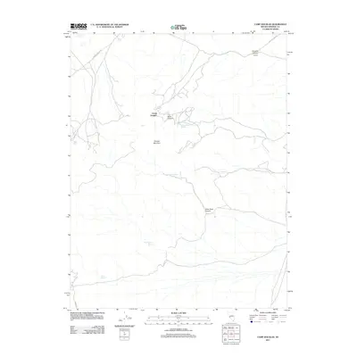
2011 Map of Camp Douglas
USGS Topo · Published 2011About this map
Camp Douglas occupies a central position in this high-desert landscape of Mineral County, Nevada, situated where the terrain begins to rise toward the prominent heights of Thunder Mountain. This 2011 survey documents a network of canyons and springs that have historically supported life and travel in this arid environment. Significant drainage features like Douglas Canyon, Rebel Canyon, and the distinctively named Silver Dyke Canyon carve through the topography, while a series of reliable water sources including White Rock Spring, Silver Dyke Spring, and Moho Spring are scattered across the quadrangle. Transportation is defined by a few key corridors such as Garfield Flats Rd and Moho Rd, which provide access through the open basins and towards the mountain flanks. The map also indicates a boundary for Virginia in the northern reaches, reflecting the complex layering of place names and administrative areas in the Great Basin.
Find a feature on this map
13 named features on this map. Tap any name to fly to it.
Don’t see what you’re looking for? This feature index may not catch every label — zoom into the map to look around manually.
Map Details
Editions of this 2011 Camp Douglas Map
This is the sole edition of this map. No revisions or reprints were ever made.
Other maps of this area

1909 · Hawthorne
USGS Topo · 1:250,000

1911 · Hawthorne
USGS Topo · 1:250,000

1915 · Hawthorne
USGS Topo · 1:250,000

1948 · Walker Lake
USGS Topo · 1:250,000

1957 · Walker Lake
USGS Topo · 1:250,000

1962 · Walker Lake
USGS Topo · 1:250,000

1964 · Walker Lake
USGS Topo · 1:250,000

1967 · Moho Mountain
USGS Topo · 1:24,000
1967 · Candelaria
USGS Topo · 1:24,000

1967 · Mina NW
USGS Topo · 1:24,000