
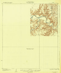
1932 Map of Camp Springs
USGS Topo · Published 1932About this map
The Double Mountain Fork Brazos River cuts a deeply etched path across the border of Kent and Fisher Counties, where this 1932 edition reveals a landscape largely defined by its drainage systems. Produced by the Board of Water Engineers and the U.S. Geological Survey, the map highlights the rugged topography surrounding Deep Creek and the broader Longhorn Valley. A notable human landmark is the County Line Sch, positioned near the western boundary. This survey is particularly interesting as a preliminary edition, with a significant portion of the sheet designated as a Preliminary Edition Unsurveyed Area, reflecting the ongoing efforts of the era to document the rural Texas interior using early aerial photography from the Air Corps.
Find a feature on this map
6 named features on this map. Tap any name to fly to it.
Don’t see what you’re looking for? This feature index may not catch every label — zoom into the map to look around manually.
Map Details
Editions of this 1932 Camp Springs Map
2 editions found
Other maps of this area

1893 · Roby
USGS Topo · 1:125,000

1926 · Snyder 1-a
USGS Topo · 1:48,000

1926 · Roby 2-b
USGS Topo · 1:48,000

1931 · Rotan
USGS Topo · 1:62,500

1952 · Hermleigh
USGS Topo · 1:24,000

1954 · Lloyd Mountain
USGS Topo · 1:24,000

1954 · Lubbock
USGS Topo · 1:250,000

1954 · Big Spring
USGS Topo · 1:250,000

1958 · Big Spring
USGS Topo · 1:250,000

1968 · Double Mountains
USGS Topo · 1:24,000