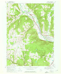
1969 Map of Campbell
USGS Topo · Published 1976About this map
The Cohocton River valley serves as the primary corridor for development and transport through Steuben County in the late 1960s. The Erie-Lackawanna railroad tracks and multiple highway routes parallel the river, connecting the settlements of Campbell, Curtis, and Coopers Plains. This transportation-heavy valley is flanked by significant elevation changes, notably at Rising Hill and Wood Hill, where the land rises sharply from the riverbank into deeply incised drainages like Curtis Hollow and Frog Hollow Creek.
Find a feature on this map
43 named features on this map. Tap any name to fly to it.
Don’t see what you’re looking for? This feature index may not catch every label — zoom into the map to look around manually.
Map Details
Editions of this 1969 Campbell Map
Other maps of this area

1903 · Hammondsport
USGS Topo · 1:62,500

1910 · Bath
USGS Topo · 1:62,500

1914 · Corning
USGS Topo · 1:62,500

1924 · Woodhull
USGS Topo · 1:48,000

1926 · Woodhull
USGS Topo · 1:62,500

1944 · Woodhull
USGS Topo · 1:62,500

1944 · Corning
USGS Topo · 1:62,500

1950 · Elmira
USGS Topo · 1:250,000

1953 · Campbell
USGS Topo · 1:24,000

1953 · Bradford
USGS Topo · 1:24,000