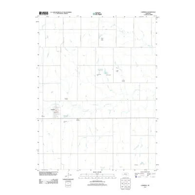
2011 Map of Campbell
USGS Topo · Published 2011About this map
Campbell and its surrounding agricultural plains in Franklin County are defined by the meandering course of the Little Blue River and an extensive network of rural infrastructure. The landscape is dotted with private water management features, including the Genereux Reservoir, Lutkemeier Reservoir, and Hoffman Reservoir, each supported by dedicated dams that reflect the importance of water storage in this Nebraska prairie region. These water features, alongside the RS AG - Land Airport, highlight the intersection of aviation and modern farming needs.
Find a feature on this map
32 named features on this map. Tap any name to fly to it.
Don’t see what you’re looking for? This feature index may not catch every label — zoom into the map to look around manually.
Map Details
Editions of this 2011 Campbell Map
This is the sole edition of this map. No revisions or reprints were ever made.
Other maps of this area

1897 · Red Cloud
USGS Topo · 1:125,000

1940 · Red Cloud
USGS Topo · 1:62,500

1942 · Red Cloud
USGS Topo · 1:62,500

1955 · Grand Island
USGS Topo · 1:250,000

1957 · Grand Island
USGS Topo · 1:250,000

1958 · Grand Island
USGS Topo · 1:250,000

1969 · Upland SE
USGS Topo · 1:24,000
1969 · Holstein
USGS Topo · 1:24,000
1969 · Roseland
USGS Topo · 1:24,000
1969 · Campbell
USGS Topo · 1:24,000