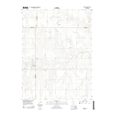
2014 Map of Campbell
USGS Topo · Published 2014About this map
Campbell sits at the intersection of Franklin and Webster counties, serving as a primary hub in this agricultural landscape near the Little Blue River. The surrounding prairie is defined by a systematic grid of section roads and a series of managed water bodies, including Genereux Reservoir, Hoffman Reservoir, and Lutkemeier Reservoir. These water resources, along with the Ray Reservoir to the south, highlight the importance of water management for the regional farming economy. For genealogists and local historians, the area is notable for several well-preserved burial grounds, such as Saint Ann Cem, Harmony Cem, Campbell Cem, and Koch Cem. The presence of the RS Ag-Land Airport north of the county line further emphasizes the modern role of aviation in supporting the local agricultural industry during the early twenty-first century.
Find a feature on this map
43 named features on this map. Tap any name to fly to it.
Don’t see what you’re looking for? This feature index may not catch every label — zoom into the map to look around manually.
Map Details
Editions of this 2014 Campbell Map
This is the sole edition of this map. No revisions or reprints were ever made.
Other maps of this area

1897 · Red Cloud
USGS Topo · 1:125,000

1940 · Red Cloud
USGS Topo · 1:62,500

1942 · Red Cloud
USGS Topo · 1:62,500

1955 · Grand Island
USGS Topo · 1:250,000

1957 · Grand Island
USGS Topo · 1:250,000

1958 · Grand Island
USGS Topo · 1:250,000

1969 · Upland SE
USGS Topo · 1:24,000
1969 · Holstein
USGS Topo · 1:24,000
1969 · Roseland
USGS Topo · 1:24,000
1969 · Campbell
USGS Topo · 1:24,000