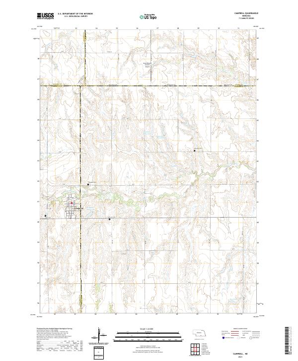
2021 Map of Campbell
USGS Topo · Published 2021About this map
The village of Campbell serves as the focal point for this landscape where the borders of Franklin, Webster, Kearney, and Adams counties meet. The terrain is defined by the winding course of the Little Blue River, which supports a network of rural water management features including Genereux Reservoir and Hoffman Reservoir. Local history is anchored by several community landmarks, notably Saint Ann Cem and Koch Cem, which sit on the outskirts of the primary settlement. The survey illustrates a highly organized agricultural grid, punctuated by transit hubs like the Nebraskaland Aviation Airport and a system of lettered and named roads such as Blue Valley Rd and Morrisville Ave. This layout reflects a modern Great Plains ranching and farming community built upon a foundation of early pioneer-era land divisions.
Find a feature on this map
32 named features on this map. Tap any name to fly to it.
Don’t see what you’re looking for? This feature index may not catch every label — zoom into the map to look around manually.
Map Details
Editions of this 2021 Campbell Map
This is the sole edition of this map. No revisions or reprints were ever made.
Other maps of this area

1897 · Red Cloud
USGS Topo · 1:125,000

1940 · Red Cloud
USGS Topo · 1:62,500

1942 · Red Cloud
USGS Topo · 1:62,500

1955 · Grand Island
USGS Topo · 1:250,000

1957 · Grand Island
USGS Topo · 1:250,000

1958 · Grand Island
USGS Topo · 1:250,000

1969 · Upland SE
USGS Topo · 1:24,000
1969 · Holstein
USGS Topo · 1:24,000
1969 · Roseland
USGS Topo · 1:24,000
1969 · Campbell
USGS Topo · 1:24,000