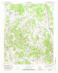
1949 Map of Campbells Station
USGS Topo · Published 1982About this map
Elk Ridge and Pea Ridge anchor this landscape south of Columbia, where the transition between Maury, Marshall, and Giles counties is defined by a dense network of family-named hollows and creek branches. The Louisville And Nashville railroad corridor serves as a primary artery, passing through the village of Culleoka and past the Dodson Siding. This mid-century survey reveals a highly localized rural community structure, where numerous family cemeteries like the Ballanfant Cem, Amis Cem, and Fitzpatrick Cem are situated on private landholdings. Educational and spiritual life is centered around landmarks such as the Mooresville School and Fountain Creek Church. The complex drainage of Fountain Creek and Bear Creek dictates the placement of settlements like Campbells Station and Mooresville, illustrating how the limestone-rich terrain of Middle Tennessee influenced nineteenth and early twentieth-century development.
Find a feature on this map
70 named features on this map. Tap any name to fly to it.
Don’t see what you’re looking for? This feature index may not catch every label — zoom into the map to look around manually.
Map Details
Editions of this 1949 Campbells Station Map
This is the sole edition of this map. No revisions or reprints were ever made.
Other maps of this area

1901 · Colombia
USGS Topo · 1:125,000

1936 · Milky Way
USGS Topo · 1:24,000

1936 · Cornersville
USGS Topo · 1:24,000

1936 · Lewisburg
USGS Topo · 1:24,000

1936 · Brick Church
USGS Topo · 1:24,000

1936 · Verona
USGS Topo · 1:24,000

1936 · Campbells Station
USGS Topo · 1:24,000

1936 · Glendale
USGS Topo · 1:24,000

1936 · Columbia
USGS Topo · 1:24,000

1936 · Lynnville
USGS Topo · 1:24,000