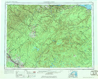
1963 Map of Campbellton
USGS Topo · Published 1963About this map
Chaleur Bay and the wooded uplands of the Restigouche Game Refuge dominate this 1963 survey of the northern borderlands. The industrial and transit corridor follows the Canadian National rail lines, connecting coastal centers like Campbellton and Dalhousie to the inland agricultural and logging hubs of St-Quentin and Kedgwick. In the southern reaches, the landscape rises toward high peaks including Mt Carleton and Sagamook Mtn, punctuated by a network of fire towers such as Fire tower #2149 that once monitored these timberlands.
Find a feature on this map
190 named features on this map. Tap any name to fly to it.
Don’t see what you’re looking for? This feature index may not catch every label — zoom into the map to look around manually.
Map Details
Editions of this 1963 Campbellton Map
3 editions found
Other maps of this area

1921 · Van Buren
USGS Topo · 1:250,000

1927 · Stockholm
USGS Topo · 1:48,000

1929 · Caribou
USGS Topo · 1:48,000

1930 · Fort Fairfield
USGS Topo · 1:48,000

1931 · Van Buren
USGS Topo · 1:48,000

1931 · Stockholm
USGS Topo · 1:62,500

1932 · Caribou
USGS Topo · 1:62,500

1933 · Fort Fairfield
USGS Topo · 1:62,500

1934 · Van Buren
USGS Topo · 1:62,500

1938 · Grand Isle
USGS Topo · 1:62,500