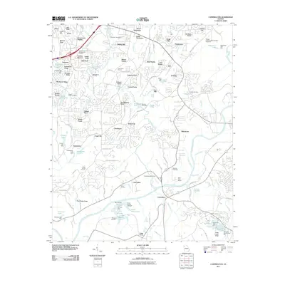
2011 Map of Campbellton
USGS Topo · Published 2011About this map
The Chattahoochee River corridor dominates this landscape southwest of Atlanta, where the historic settlement of Campbellton sits near a bend in the water. By the early 21st century, the area shows a dense network of suburban subdivisions such as Anneewakee Heights, Dogwood Acres, and Heritage Valley, reflecting the significant residential expansion into Douglas and Fulton Counties. Aviation and recreation are prominent, with both the Chattahoochee Air Park and Miller Farm Airport serving the region, alongside the West Atlanta Raceway near Warren Heights. Local history is preserved in sites like the Holly Springs Cemetery and McKoy Cemetery. The map also details an extensive system of small lakes and reservoirs, including Sweetwater Lake and the Douglasville Lake system, which manage the local tributaries feeding into the Chattahoochee.
Find a feature on this map
138 named features on this map. Tap any name to fly to it.
Don’t see what you’re looking for? This feature index may not catch every label — zoom into the map to look around manually.
Map Details
Editions of this 2011 Campbellton Map
This is the sole edition of this map. No revisions or reprints were ever made.
Other maps of this area

1891 · Marietta
USGS Topo · 1:125,000

1895 · Marietta
USGS Topo · 1:125,000

1897 · Marietta
USGS Topo · 1:125,000

1901 · Marietta
USGS Topo · 1:125,000

1953 · Atlanta
USGS Topo · 1:250,000

1954 · Palmetto
USGS Topo · 1:24,000

1954 · Campbellton
USGS Topo · 1:24,000
1954 · Mableton
USGS Topo · 1:24,000

1954 · Fairburn
USGS Topo · 1:24,000

1954 · Austell
USGS Topo · 1:24,000